bo - programa Fantastico - 07/02/2010: Estranhas formas surgem na Floresta Amazônica
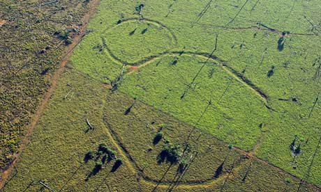
Formas perfeitas escavadas no solo, espalhadas pelo extremo oeste da Amazônia, surgiram com o desmatamento para criação de gado. Chamados de geóglifos, os desenhos impressionam pela perfeição.TV Glo
Equipe de reportagem visitou geoglifos no Acre e no Amazonas. Confira mapa de satélite com os misteriosos desenhos ancestrais.
Elas passaram séculos escondidas pela floresta. Agora, com o desmatamento para a criação de gado, estão aparecendo cada vez mais. Os geoglifos são formas perfeitas escavadas no solo, espalhadas pelo extremo oeste da Amazônia.
Serão vestígios de uma sociedade desconhecida? Ou restos do lendário reino de Eldorado, com que tantos exploradores sonharam?
Segundo o paleontólogo Alceu Ranzi, da Universidade Federal do Acre, os geoglifos formavam um grande sistema que se estendia por centenas de quilômetros nessa região da Amazônia. Ranzi fazia parte da equipe que descobriu os desenhos, em 1977. Mas foi só nos últimos tempos que o número de achados disparou, graças a fotos de satélite disponíveis na internet. Já são quase 300 geoglifos - de alguns, os pesquisadores nunca chegaram perto.
Apesar do nome, Boca do Acre fica no Amazonas. É para lá que foi a equipe de reportagem do Fantástico, para ver de perto alguns geoglifos que até então só haviam sido observados pelo pesquisadores por imagens de satélite.
Em pouco tempo de voo é possível ver as formas - algumas bem nítidas, outras parcialmente encobertas pela mata. “Normalmente são quadrados e círculos. Temos octógonos também, hexágonos...”, cita Ranzi.
Para Jacob Queiroz, 93 anos, dono de terras onde existem algumas figuras, elas não podem ser simples obras da natureza. “Isso aqui foi gente que fez. Trabalho de engenheiro”, comenta.
Dentro de um dos canais que forma as figuras, é possível ver que a terra foi escavada e cuidadosamente empilhada do lado de fora. Por isso, chegou-se a pensar que as valas seriam trincheiras da revolução acriana, a revolta do início do século 20 contra a dominação da Bolívia no território.
Mas a teoria das trincheiras está fora de cogitação. As análises geológicas publicadas mostram que os geoglifos são muito mais antigos: do século 13.
Outra questão intrigante é como os habitantes daquela época conseguiram fazer isso dentro de uma floresta densa. “Imagino que essa região da Amazônia devia estar passando por um problema climático”, diz Ranzi. Os cientistas têm uma hipótese: na época da construção dos geoglifos, a Amazônia pode ter passado por uma seca muito forte, que transformou a floresta numa imensa savana, parecida com o cerrado brasileiro.
Falta ainda a principal peça do quebra-cabeça: que tipo de sociedade projetou esses monumentos? Certamente devia ter um certo grau de organização para elaborar esses monumentos. As principais teorias sobre os povos que viviam nesta região antes de o Brasil ser descoberto dizem que esses povos jamais teriam tamanha sofisticação, eram nômades, ou seja, não passavam muito tempo no mesmo lugar.
Para Jacó Piccoli, antropólogo da Universidade Federal do Acre, é possível que haja uma relação estreita com os antepassados dos índios atuais. “Mas podem ter sido também outras populações que habitaram a região”, pondera. É difícil estabelecer uma origem clara para os geoglifos, porque não se encontram pistas nas tradições dos índios que vivem hoje na região.
Na falta de respostas, os moradores abraçam o sobrenatural. Seu Jacob conta que, estranhamente, as valas nunca alagam quando chove e que, do chão, sobe uma espécie de zumbido. “Uuuuuu.... que nem uma abelhal”, conta.
Também não faltam suposições delirantes, como, por exemplo, que os geoglifos seriam marcas deixadas por extraterrestres.
Quando olham para a imensidão da floresta amazônica preservada, os cientistas ficam imaginando quantos geoglifos, quantos desenhos geométricos estão escondidos debaixo das árvores. Eles estimam que nem 10% deles tenham sido revelados.
via G1
Amazon explorers uncover signs of a real El Dorado
Spanish conquistadores ventured into the rainforest seeking fortune, followed over the centuries by others convinced they would find a lost civilisation to rival the Aztecs and Incas.
Some seekers called it El Dorado, others the City of Z. But the jungle swallowed them and nothing was found, prompting the rest of the world to call it a myth. The Amazon was too inhospitable, said 20th century scholars, to permit large human settlements.
Now, however, the doomed dreamers have been proved right: there was a great civilisation. New satellite imagery and fly-overs have revealed more than 200 huge geometric earthworks carved in the upper Amazon basin near Brazil's border with Bolivia.
Spanning 155 miles, the circles, squares and other geometric shapes form a network of avenues, ditches and enclosures built long before Christopher Columbus set foot in the new world. Some date to as early as 200 AD, others to 1283.
Scientists who have mapped the earthworks believe there may be another 2,000 structures beneath the jungle canopy, vestiges of vanished societies.
The structures, many of which have been revealed by the clearance of forest for agriculture, point to a "sophisticated pre-Columbian monument-building society", says the journal Antiquity, which has published the research.
The article adds: "This hitherto unknown people constructed earthworks of precise geometric plan connected by straight orthogonal roads. The 'geoglyph culture' stretches over a region more than 250km across, and exploits both the floodplains and the uplands … we have so far seen no more than a tenth of it."
The structures were created by a network of trenches about 36ft (nearly 11 metres) wide and several feet deep, lined by banks up to 3ft high. Some were ringed by low mounds containing ceramics, charcoal and stone tools. It is thought they were used for fortifications, homes and ceremonies, and could have maintained a population of 60,000 – more people than in many medieval European cities.
The discoveries have demolished ideas that soils in the upper Amazon were too poor to support extensive agriculture, says Denise Schaan, a co-author of the study and anthropologist at the Federal University of Pará, in Belém, Brazil. She told National Geographic: "We found this picture is wrong. And there is a lot more to discover in these places, it's never-ending. Every week we find new structures."
Many of the mounds were symmetrical and slanted to the north, prompting theories that they had astronomical significance.
Researchers were especially surprised that earthworks in floodplains and uplands were of a similar style, suggesting they were all built by the same culture.
"In Amazonian archaeology you always have this idea that you find different peoples in different ecosystems," said Schaan. "So it was odd to have a culture that would take advantage of different ecosystems and expand over such a large region." The first geometric shapes were spotted in 1999 but it is only now, as satellite imagery and felling reveal sites, that the scale of the settlements is becoming clear. Some anthropologists say the feat, requiring sophisticated engineering, canals and roads, rivals Egypt's pyramids.
The findings follow separate discoveries further south, in the Xingu region, of interconnected villages known as "garden cities". Dating between 800 and 1600, they included houses, moats and palisades.
"These revelations are exploding our perceptions of what the Americas really looked liked before the arrival of Christopher Columbus," said David Grann, author of The Lost City of Z, a book about an attempt in the 1920s to find signs of Amazonian civilizations. "The discoveries are challenging long-held assumptions about the Amazon as a Hobbesian place where only small primitive tribes could ever have existed, and about the limits the environment placed on the rise of early civilisations."
They are also vindicating, said Grann, Percy Fawcett, the explorer who
partly inspired Conan Doyle's book The Lost World. Fawcett led an
expedition to find the City of Z but the party vanished, bequeathing a
mystery.
Many scientists saw the jungle as too harsh to sustain anything but small nomadic tribes. Now it seems the conquistadores who spoke of "cities that glistened in white" were telling the truth. They, however, probably also introduced the diseases that wiped out the native people, leaving the jungle to claim – and hide – all trace of their civilisation.
• This article was amended on Wednesday 6 January 2010. Percy Fawcett's experiences in the Amazon were said to have partly inspired Arthur Conan Doyle's book The Lost World, but Fawcett's disappearance did not, contrary to a suggestion in the original article - he vanished after the book was published. This has been corrected.
via The Guardian





0 comentários:
Postar um comentário