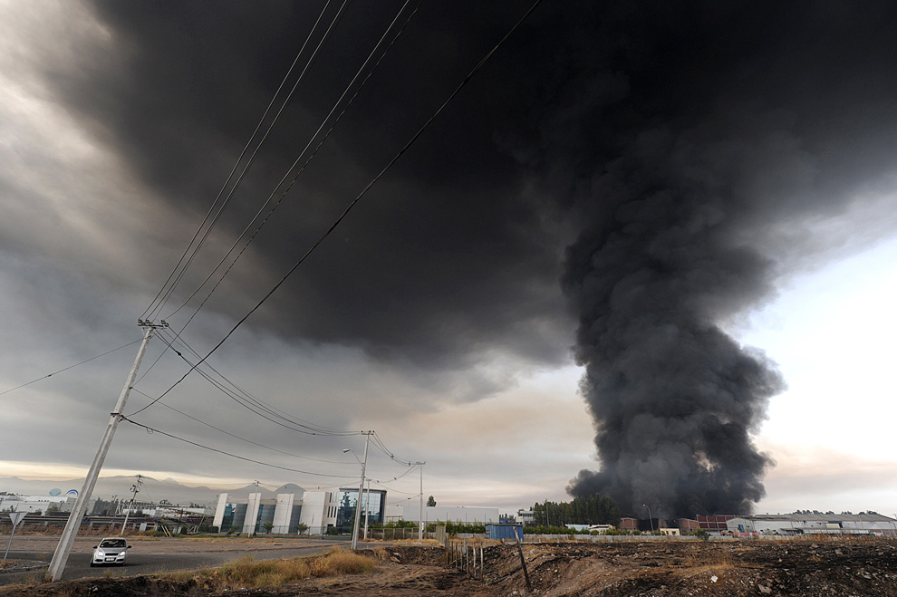
Smoke from a burning building fills the sky in the outskirts of Santiago after a huge 8.8-magnitude earthquake rocked Chile on February 27, 2010.
foto de Martin Bernetti/AFP
foto de Martin Bernetti/AFP
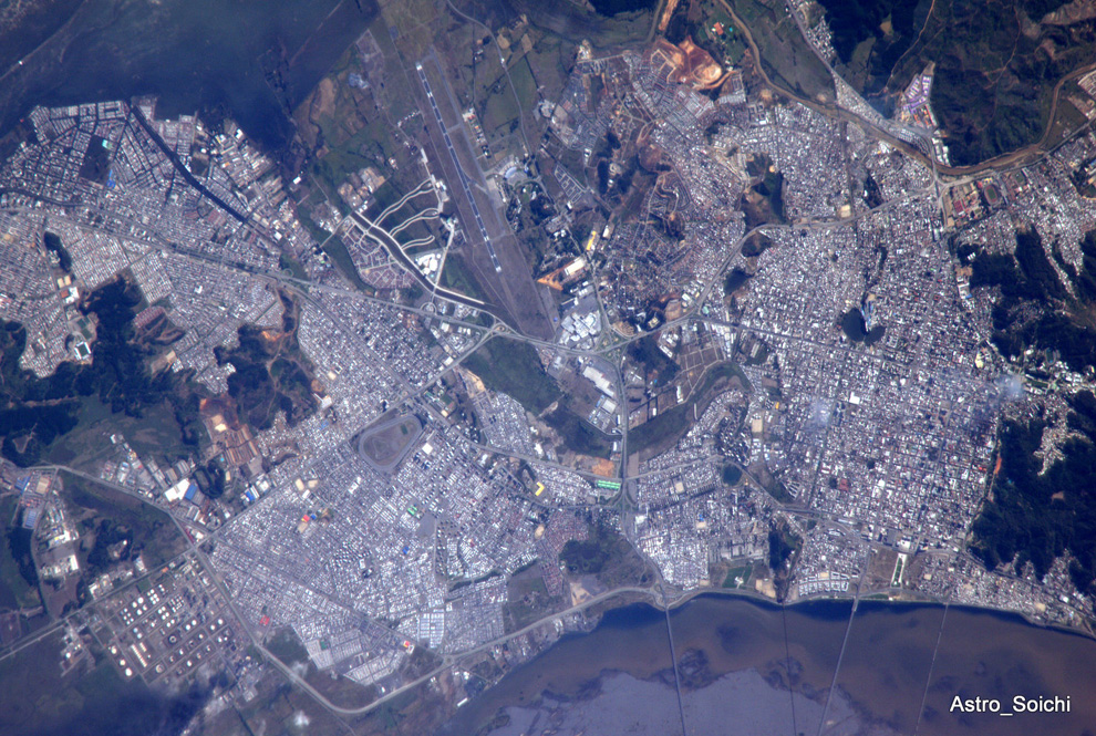
Photograph taken this morning of Concepcion, Chile by astronaut Soichi Noguchi, aboard the International Space Station: "Concepcion, Chile. Mega earthquake (M8.3) hit this city this morning. Photo taken a few hours ago. We pray for you." via TwitPic foto de Shoichi Nogucht
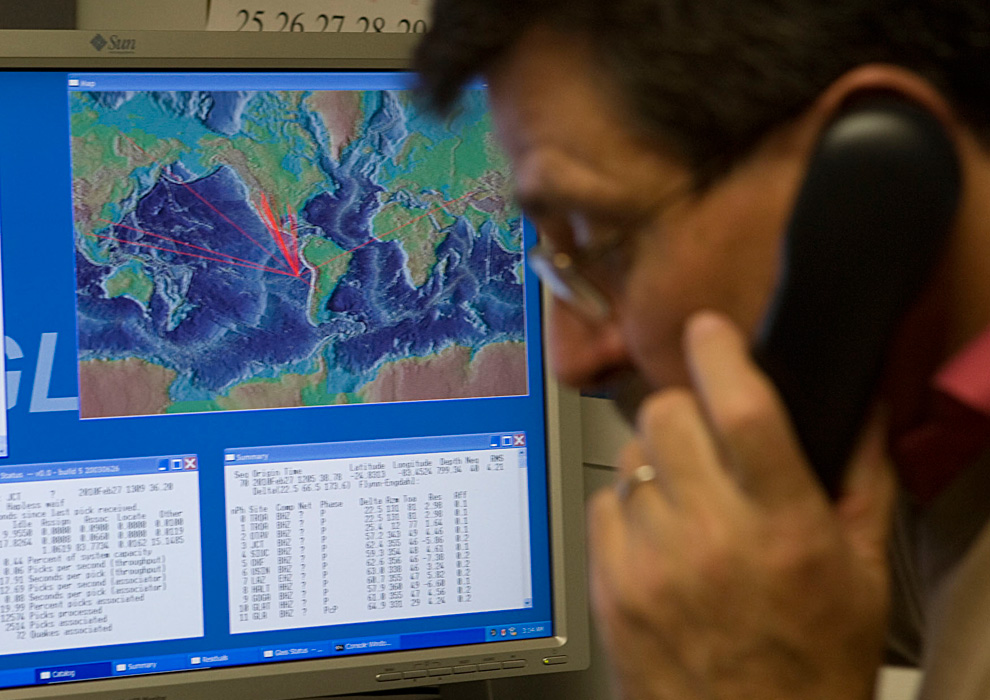
With a computer graphic showing the possible path of tsunami waves from an earthquake in Chile, Dr. Charles McCreery speaks on the phone at the Pacific Tsunami Warning Center, Saturday, Feb. 27, 2010 in Ewa Beach, Hawaii. The State of Hawaii is under a tsunami warning after an 8.8 magnitude earthquake rattled Chile today.
fot de Marco Garcia/AP
Sabe-se que atingiu 8.8 na escala de Richter, que morreram pessoas, há vários feridos e muita coisa destruída, incluindo na cidade de Santiago. Pelo que pude perceber, números e outros dados são ainda confusos e bastante contraditórios.
Tentarei ir actualizando este post, embora não prometa mais que 'copy+past', com as informações, links e sites que me parecerem mais úteis.

[ACTUALIZAÇÃO]
Coberturas de Media do Chile:
- follow live-blog coverage of the earthquake aftermath on the Web sites of the Chilean newspapers La Tercera and El Mercurio.
- La Tercera also has video, photos and reactions from world leaders on its home page, along with audio of Chile’s interior minister, Pérez Yoma, describing the country’s response to the earthquake.
- Carmen Fernández, the director of Chile’s emergency response office, Onemi
More on the Earthquake:
- Underwater Plate Cuts 400-Mile Gash
- this map, showing where the epicenter of the earthquake was
- Maps of the Chile Earthquake
- a selection of readers’ photographs from the earthquake in Chile
- Facebook | Twitter: Earthquake | Tsunami
- Disaster Awaits Cities in Quake Zones (Feb. 25)
- Google | Person Finder: Chile Earthquake
- chile-earthquake | Colectânea 'Twittpics User's Photos' via Mashable
- Twitter: #terramotochile
- Video From MSNBC
- Readers' Photos
- Photographs
- How to help Chile

USGS A map showing the location of Saturday’s 8.8 magnitude earthquake off the coast of Chile from the Web site of the U.S. Geological Survey.
- La Tercera, reports in its excellent minute by minute coverage of the earthquake aftermath
- ABC News reports:
- The Times’s Martin Fackler reports from Tokyo.
- The Japan Meteorological Agency reported Sunday afternoon that the first waves from the tsunami washed ashore on a tiny island far southeast of Tokyo, Minami Torishima.
- Chile is on a hotspot of sorts for earthquake activity, according to a Live Science report.
- This video, from Terra TV, was shot by a crew that was out filming a report early on Saturday morning about the Viña del Mar music festival, in a town northwest of Chile’s capital, when the earthquake struck
- Hawaii’s tsunami warning sirens sounded earlier today, just as an official at the Pacific Tsunami Warning Center was giving a briefing to a local news station. On Facebook, one resident of Honolulu posted video he shot after the alert started, with hte comment, “So, the tsunami siren was a little alarming.”
- KHON, another local news station in Hawaii, is also streaming video of their coverage
- KHON, a local news station in Hawaii is streaming video of their coverage as the islands prepare for a possible tsunami there.
- The BBC has published video from Chilean TV in which earthquake survivors described the terror caused by the huge earthquake.
- National Weather Service’s Pacific Tsunami Warning Center: most recent bulletin
- Chileans have been uploading and sharing photos via Twitter and Twitpic.Social media news site Mashable has compiled a collection.
- As it did after the earthquake in Haiti, Google has set up an online tool to help people searching for missing relatives and friends share information. Embedded below are links for readers who want to access to that database. Person Finder: Chile Earthquake
- VIDEO: Quake Damage in Chile
- VIDEO: Seeking Help in Chile
- VIDEO: Obama Says U.S. Ready to Assist Chile
“TSUNAMI WARNING CANCELLATION.” It states:
BASED ON ALL AVAILABLE DATA THERE IS NO LONGER A DESTRUCTIVE TSUNAMI THREAT TO THE STATE OF HAWAII. THEREFORE THE TSUNAMI WARNING FOR HAWAII IS CANCELED.
HOWEVER SOME COASTAL AREAS IN HAWAII MAY CONTINUE TO EXPERIENCE SMALL SEA LEVEL CHANGES AND STRONG OR UNUSUAL CURRENTS LASTING FOR SEVERAL MORE HOURS.
Here is video of President Obama’s remarks earlier this afternoon at the White House:
Kristina Wong of ABC News reported that Mr. Obama had met earlier in the day with officials in the White House situation room as his home state of Hawaii prepared for potentially deadly tsunami waves triggered by the earthquake.
The Associated Press obtained video from surveillance cameras in Chile’s capital, showing the shaking caused by the earthquake early on Saturday, more than 200 miles from the epicenter:
1:32 p.m. |Estimated Arrival Times of Tsunami Waves
The Web site of the American West Coast and Alaska Tsunami Warning Center posted this map with estimated arrival times of tsunami waves generated by Saturday morning’s earthquake off the coast of Chile:

NOAA Estimated travel times for tsunami waves generated by Saturday’s 8.8 magnitude earthquake off the coast of Chile. Enlarge.
Unlike an earlier map from the same source that we posted, which was used for a drill in 2006, this is a forecast based on today’s earthquake.The Tsunami Warning Center’s Web site also has data on tsunami waves that have already been observed along the coast of South America.
The Web site of the U.S. Geological Survey has a lot of information about the 1960 earthquake in a fascinating and useful report called “Surviving a Tsunami—Lessons from Chile, Hawaii, and Japan.”

USGS An image of the aftermath of the 1960 tsunami in Hilo, Hawaii, where the waves generated by an earthquake off Chile caused 61 deaths.
posted on the Web site of the American West Coast and Alaska Tsunami Warning Center, which is described as “the preliminary forecast model energy map,” for the Pacific, following Saturday morning’s huge earthquake off the coast of Chile:
The Tsunami Warning Center has a very detailed list of estimated arrival times for waves generated by Saturday’s 8.8 magnitude earthquake at many locations along the west coast of the United States.
The same Web site also has this map, which was produced for a Pacific-wide tsunami drill conducted in May, 2006 with estimated arrival times for waves produced by hypothetical magnitude 9.2 earthquake off the coast of central Chile:

Map of estimated tsunami wave arrival times, in hours after a hypothetical 9.2 magnitude earthquake used in a tsunami drill in 2006. Enlarge.
Philippines orders limited evacuation | 8:48 p.m. ET
Philippines orders limited evacuation | 8:48 p.m. ET
Reuters reports that the Philippines government has ordered a precautionary evacuation on Sunday along its eastern seaboard after raising the level of a tsunami alert.
"At 7 a.m. today, we raised the tsunami alert to level 2 and People are advised to stay away from beaches and to report unusual big waves in their areas," Renato Solidum, director of the Philippine Institute of Volcanology and Seismology, told Reuters.
"There's only limited evacuation in some areas where communities are near the water," he said, adding local officials have the authority to force residents to move to safer areas.
And in Australia, the possibility of a tsunami apparently didn’t deter beach-goers, according to newspaper reports.
From the Web site of Britain’s Channel 4 News, here is video shot early this morning of a fire in Chile’s second-largest city, Concepcion, which is located just 70 miles from the epicenter of the earthquake:
Here is MSNBC’s live coverage, which, at the moment, appears to be devoted to a stream of coverage from Hawaii:This footage, obtained by The Associated Press, was shot in Santiago this morning, more than 200 miles from the epicenter of the earthquake:
This video report from ITN News in Britain shows some earlier images from the pre-dawn hours in Chile:
About one hour ago, Reuters reported that a bulletin from the Pacific Tsunami Warning Center said: “Urgent action should be taken to protect lives and property.” The warning also noted: “All shores are at risk no matter which direction they face.”
The latest alert from the Pacific Tsunami Warning Center, issued on Saturday morning, says “a widespread tsunami warning is in effect.”
The bulletin says:
SEA LEVEL READINGS CONFIRM THAT A TSUNAMI HAS BEEN GENERATED WHICH COULD CAUSE WIDESPREAD DAMAGE. AUTHORITIES SHOULD TAKE APPROPRIATE ACTION IN RESPONSE TO THIS THREAT. THIS CENTER WILL CONTINUE TO MONITOR SEA LEVEL DATA TO DETERMINE THE EXTENT AND SEVERITY OF THE THREAT.The bulletin makes clear that the warning is in effect across much of the Pacific:
A TSUNAMI WARNING IS IN EFFECT FOR:A report on the 8.8 magnitude earthquake on the Web site of the U.S. Geological Survey says that it took place at 3:34:14 a.m. local time 21.7 miles beneath the earth’s surface, about 70 miles northeast of Concepcion, Chile’s second-largest city, home to more than 200,000 people, and about 200 miles southwest of the country’s capital, Santiago. The U.S.G.S. puts the earthquake, which was nearly 500 times as strong as the one that hit Haiti last month, in historical perspective:
CHILE / PERU / ECUADOR / COLOMBIA / ANTARCTICA / PANAMA / COSTA RICA / NICARAGUA / PITCAIRN / HONDURAS / EL SALVADOR / GUATEMALA / FR. POLYNESIA / MEXICO / COOK ISLANDS / KIRIBATI / KERMADEC IS / NIUE / NEW ZEALAND / TONGA / AMERICAN SAMOA / SAMOA / JARVIS IS. / WALLIS-FUTUNA / TOKELAU / FIJI / AUSTRALIA / HAWAII / PALMYRA IS. / TUVALU / VANUATU / HOWLAND-BAKER / NEW CALEDONIA / JOHNSTON IS. / SOLOMON IS. / NAURU / MARSHALL IS. / MIDWAY IS. / KOSRAE / PAPUA NEW GUINEA / POHNPEI / WAKE IS. / CHUUK / RUSSIA / MARCUS IS. / INDONESIA / N. MARIANAS / GUAM / YAP / BELAU / JAPAN / PHILIPPINES / CHINESE TAIPEI
Coastal Chile has a history of very large earthquakes. Since 1973, there have been 13 events of magnitude 7.0 or greater. The February 27 shock originated about 230 km north of the source region of the magnitude 9.5 earthquake of May, 1960 – the largest instrumentally recorded earthquake in the world. This magnitude 9.5 earthquake killed 1655 people in southern Chile and unleashed a tsunami that crossed the Pacific, killing 61 people in Hawaii, Japan, and the Philippines. Approximately 870 km to the north of the February 27 earthquake is the source region of the magnitude 8.5 earthquake of November, 1922. This great quake significantly impacted central Chile, killing several hundred people and causing severe property damage. The 1922 quake generated a 9-meter local tsunami that inundated the Chile coast near the town of Coquimbo; the tsunami also crossed the Pacific, washing away boats in Hilo harbor, Hawaii. The magnitude 8.8 earthquake of February 27, 2010 ruptured the portion of the South American subduction zone separating these two massive historical earthquakes.The Honolulu Advertiser has live video of Waikiki Beach and frequent updates on its Web site, as the islands brace for the impact of potentially dangerous tsunami waves.
A large vigorous aftershock sequence can be expected from this earthquake.
This live video from Hawaii is being fed by a CBS affiliate there :
As we noted earlier, KHON, another local news station in Hawaii, is also streaming video of their coverage


0 comentários:
Postar um comentário